
|
- our favoured places |
|
|
|
||

Around Christchurch
Spencerville, North Beach
This is the preferred spot for Canterbury members, following negotiations with authorities in early 2008, the beach 150 m north of the Heyders Rd entrance is now the recognised area. However, recently there have been reports of bad behaviour!
We are serious about being absolutely family friendly!
If you see bad behviour at the beach, please advise advise the police directly of any associated car registration number and/or get an identifying photo, if possible!
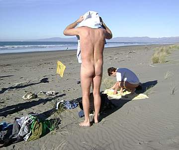
A good day for the first local mid-winter swim.
From the Christchurch CBD, go north about 15km, turning off SH 1 right into Lower Styx Road. Use the Heyders Rd entrance and go north (left) 150 m up the beach - and don't forget your flag!
Woodend Beach
This used to be the preferred spot for Canterbury members, but following negotiations with the police in early 2008, the northern side of Spencerville has taken its place.
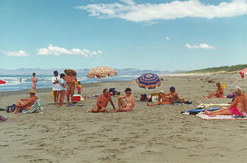
This is a fairly typical 'day at the beach' scene for us.
From SH1, 24km north of Christchurch, turn off at Woodend (signposted) and go 3km to the beach. Walk to your left. A wide sandy beach backed by sand dunes and pines. There is plenty of shelter from the wind in the dunes if it happens to be windy. Motor camp. Store and petrol at Woodend. Shop at the beach car park.
Taylors Mistake
Actually this part is called Hobson Bay. It's just around to the left from Taylors Mistake 'proper' (where the Surf Club building is).
This spot looses the sun in the late afternoon
From Christchurch drive out to Sumner, continue 3km over Scarborough Hill and park behind the surf club. Sunbathe at either side of the beach - or try Hobson Bay just round to the left. Good swimming, but another beach which is getting more textiles these days as more areas are developed, so seems to be used by Free Beach members less.

Waikuku Beach
A good drive north of Christchurch, this used to be our 'place to go' but we now prefer Spencer Park because it's both closer to Christchurch and easier to get onto the sand.
Although Waimairi Beach (just north of New Brighton) is handy to the city, one has to walk quite a way along that beach - only to
discover then, that some of the public may be indulging in less than exemplary behaviour.
This one of several similar beach areas north of Christchurch
From SH1, north of Christchurch, turn off right (signposted) onto Waikuku Beach Rd towards the Waikuku township. At the T-intersection in the township turn right over the bridge, keep going until near the end. Turn left into Broadway St and park at the end. A gravel road continues from here to a car park directly behind the beach, but the gate is usually locked.

Leithfield Lagoon
North of Waikuku and south of Leithfield Beach, is Ashworths Beach, used by horse trainers for trotting practice. About 2km south is the top end of the lagoon - also known as Ashworths Ponds.
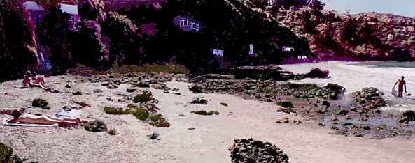
This how the lagoon looks with the tide out
Drive out north on State Highway 1 about 35 km to the sign 'Ashworths Beach Road', opposite Harlesden House. After 500m of sealed road there's a metalled road to a car park, then a 4WD track 100m onto the beach.

Tumbledown Bay
This pleasant place, probably due to it being a long way from Christchurch, on Banks Peninsular, south of Little River. We plan trips there occasionally, but otherwise it seems to be rarely used by anyone.
The long flat tidal run certainly makes it safe for kids
Take SH75 towards Akaroa. At Little River, turn right over the bridge onto Kinloch Rd. Follow until the top of the hill, take the first turn to the right and shortly thereafter turn left onto Te Oka Bay Rd (downhill). This metalled road reaches the coast and follows it to the left; do not leave the road until you reach a stream down in the valley. Park the car and follow the track down to the beach. If you reach Te Oka Bay you have gone one bay too far. At Te Oka Bay the 'no exit' road turns inland again.
Other beach directions
Camp Bay
Drive towards Governors
Bay, then Diamond Harbour. Keep going, following the road around the harbour. In
Purau, the road veers off half-right. At this point go onto Camp Bay Rd by going
straight (the road sign is difficult to see because of the angle). From here it
is soon a gravel road to the end. Ripapa Island can be seen on the
way. At Camp Bay, drive through the gate (close it behind you!) and onto the car
park. Go downhill. The main beach is at your left; turn right onto the smaller
beach at the end. There is another secluded bay past some rocks, but it has
become difficult to access lately.
Note that the secluded bay is only available
for about 1.5 hours around low tide and is otherwise under water, also Camp Bay is
becoming more popular with textiles so may be more suitable now to mid week
visits owning to the Beach being very small at high tide.
For the benefit of everyone, please let us know about any corrections, omissions, or additions to the above directions!